| |
|
|
Home
> Destinations > Montserrat > Map

Volcano exclusion zone
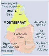 The eruption of Soufriere Hills volcano in the South of the island has led to the evacuation and relocation of residents beyond the exclusion zone. The eruption of Soufriere Hills volcano in the South of the island has led to the evacuation and relocation of residents beyond the exclusion zone.
This part of Montserrat is dangerous and is also illegal to enter. The boundary for the exclusion zone begins from the Richmond Hill area on the west coast, running eastwards over St. Georges Hill, down through the Belham Valley and over the Centre Hills through Windy Hill and Harris and down to the east coast at the site of W.H. Bramble Airport.
On the west side of Montserrat, a Daytime Entry Zone (6am to 6pm) exists southwards from Belham Valley to the boundary of the exclusion zone; this Zone includes Cork Hill, Delvins, Weekes, Richmond Hill, Foxes Bay and the top of St.Georges Hill.
|
|
|